Sde Boker

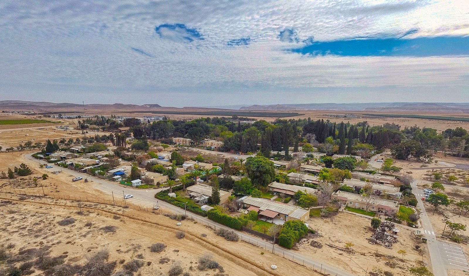
Sde Boker is a kibbutz in the Negev desert of southern Israel. Best known as the retirement home of Israel’s first Prime Minister, David Ben-Gurion, it falls under the jurisdiction of Ramat HaNegev Regional Council. A large agricultural farm or small village existed here in the early Islamic period, from the late 7th century to the early 9th century. Remains of dozens of structures exist, including a mosque near which hundreds of Arabic inscriptions were found.

The modern kibbutz was established on May, 15 1952 and 1953, Prime Minister David Ben-Gurion resigned from office and moved to the kibbutz. Although he returned to politics in 1955, he continued to live in the kibbutz until his death in 1973, when he was buried nearby at Midreshet Ben-Gurion alongside his wife Paula Ben-Gurion. Ben-Gurion moved to the kibbutz inspired by his vision of cultivating the Negev desert and building up its surrounding towns such as Yeruham and Dimona. He believed that eventually the Negev would be home to many Jews who would move to Israel, and he felt that Sde Boker was a trailblazer and example for what should follow. His home was later turned into a museum.

In his official writings Ben-Gurion often mused about his efforts at rejuvenating the Negev: “The desert provides us with the best opportunity to begin again. This is a vital element of our renaissance in Israel. For it is in mastering nature that man learns to control himself. It is in this sense, more practical than mystic, that I define our Redemption on this land. Israel must continue to cultivate its nationality and to represent the Jewish people without renouncing its glorious past. It must earn this—which is no small task—a right that can only be acquired in the desert.”

Neot Smadar

Kibbutz Neot Semadar is located in the Southern Negev Desert of Israel, about 60 km. north of Eilat. The Kibbutz was established in 1989 by a group of friends interested in creating a learning community that focuses on cooperation and creativity in daily life. As individuals in a dynamic community, the residents learn what it means to live together as co-learners, observing ourselves in everyday activities and relationships. The interest in relationships extends to the environment through organic farming, desert architecture, water recycling, The Art Center, winery, and more. Today there are 90 adult members (families and singles), 70 children of various ages, and about 50 volunteers of all ages. These volunteers, from Israel and from abroad come to Neot Semadar to find a fresh and independent perspective on life.

Mitzpe Ramon

Mitzpe Ramon was founded in 1951 as a camp for the workers building Highway 40. The town’s first permanent residents, several young families from Kibbutz Re’im and other parts of Israel began settling there in 1956. After five years, the town was home to 370 residents including 160 children, most of them veteran Israelis. There were also 180 housing units to absorb new immigrants. They were joined by immigrants from North Africa, Romania, and India in the 1960s, and it became the southernmost of the Negev’s development towns.

Conditions in the early years were harsh, with limited food supplies and practically no modern-day amenities. Ice blocks and provisions were delivered once a week by a supply truck. There was a single school with one classroom for all ages. The homes of the first settlers were prefabricated asbestos barracks. Later, rows of small attached stone houses were built and after that, apartment buildings, beginning in the early 1960s.

In 1972, Mitzpe Ramon had a population of about 1,400 people living in 300 households. The town further grew after Ramon Airbase was completed in 1982. In 1988, the town had a population of about 3,000, and it experienced more significant population growth when it absorbed Soviet immigrants during the 1990s Post-Soviet aliyah.

The development of Mitzpe Ramon was adversely affected by the opening of Route 90 in the late 1960s. After the inauguration of this highway, traffic to and from Eilat bypassed Mitzpe Ramon almost entirely. However, growing interest in ecotourism, Jeep trekking (access to Nabatean ruins), mountain biking and hiking, stargazing and the upgrading of Route 40, which is considered a more scenic route to Eilat, have improved the economy.

Jerusalem Marble, one of a few major suppliers and overseas exporters of Jerusalem stone (established in 1923), inaugurated a state-of-the-art factory in Mitzpe Ramon in January 2000. Jerusalem Stone is exported globally. Mitzpe Ramon has six hotels and dozens of bed and breakfast establishments. In 2011, the Isrotel hotel chain opened a luxury hotel, the Beresheet Hotel, in Mitzpe Ramon.

The Tourism Ministry allocated NIS 9.5 million for infrastructure development in Mitzpe Ramon, and the Ministry for the Development of the Negev and Galilee financed the construction of a landing strip for light aircraft. In December 2013, plans were proposed for a Las Vegas-style Casino in the town. The Mitzpe Ramon Jazz Club hosts musical ensembles on the weekend. On weekdays, it operates as a music school. ‘Me’ever’, a unique hostel and event space, located in the artist quarter of Mitzpe Ramon, designated to connect between creative people and interesting ideas.

Nabatian Trail | Avdat National Park

In the heart of the desert, on a hilltop above the Tsin Stream watercourse, are the impressive remains of an ancient Nabatean city. Avdat was founded by the Nabateans in the 4th century BCE. Initially it was a waystation on the Nabatean Incense Route – the ancient trade routes crossing the Arabian Peninsula to the city of Gaza and the Mediterranean Sea. These routes served the camel caravans, mainly carrying spices and incense. The city developed in the days of King Obodas II (1st century BCE), and was named after him. A temple, an army camp, and other buildings from this time have been found.

At the end of the 1st century CE, the city’s inhabitants moved over to agriculture as their main livelihood, and an inscription from this period found at the site mentions the Nabatean king Rabbel II – “Restorer and deliverer of his people”. Apparently under pressure of the heavy hand of the Romans, who damaged the Nabatean economy, he laid the foundation for the development of agriculture and animal husbandry. In the year 106 CE, after the death of the king, Avdat was annexed to the Roman empire and continued to develop. The height of its prosperity was in the Byzantine period (4th – 7th centuries CE). The city’s inhabitants converted to Christianity and built magnificent churches, developed intensive agriculture, constructed water storage systems, and dug many caves in the hillside.

The caves were used mainly as workshops and storerooms for keeping and processing the agricultural produce. Towards the end of the Byzantine period the security situation in the city was undermined. In around 630 the city was damaged by a strong earthquake, and shortly after, in 636, the area was conquered by Arab tribes. These two factors together sealed its fate and the city was abandoned.

Modern archeological study of the city began in the 19th century, and in 1870 a researcher by the name of Palmer identified the site and determined that it was the city of Avdat. Methodical archeological excavations began in 1958, under Michael Avi-Yonah and Avraham Negev, of the Hebrew University of Jerusalem. In the 1970s further excavations were carried out at the site. In the 1950s an agricultural farm was established by the city (Even-Ari Farm), in an attempt to reconstruct the ancient farming methods and ways of storing water.

Eilat Mountains

The Harei Eilat, or Eilat Mountains, offer some of the most breathtaking views and spectacular desert routes in all of Israel. This large mountain range is located just miles north of Israel’s most southern city, Eilat. Known for its stunning beauty, hikers and adventurers marvel at the rich yellow, red and brown colors of the mountain’s rocky landscape. Erosion overtime has resulted in narrow canyon areas as well, where visitors walk through spaces only one or two meters wide, but hundreds of meters high. The area is home to animals such as the Striped Hyena, Golden Jackal, and Dorcas Gazelle, and can be explored on foot or by a jeep tour.

Timna Park

One of the largest parks in Israel, Timna Park, is located in the center of the Edom Valley, in the Arava, approximately 25 km north of Eilat. The Park is home to spectacular geological sites and formations which can be explored by foot, bicycle, and car.

The recently opened Visitors Center illustrates the importance of the Park’s geological, historical, and archeologic sites, using advanced technological features. Sites to see are the archaeological remains of ​​Solomon’s Pillars, the Arches, the Chariots, the famous Mushroom Rock, the Temple of Goddess Hathor, and the “Hill of the Slaves” which offer visitors an exciting opportunity to ‘travel back in time’ to an era in which the world’s most ancient copper mines operated in Timna, thousands of years ago.

In addition, Timna offers unique entertainment options, combining ancient times with modern accommodation and leisure facilities. This new upgrade in Timna Park allows visitors of all ages, adults, children, science and nature lovers and sports addicts to have an exclusive and experiential vacation with educational benefits, with breathtaking Genesis views.

Hai-Bar Yotvata Nature Reserve

The Yotvata Hai-Bar Nature Reserve is a 3,000-acre breeding and reacclimation center administered by the Israel Nature Reserves & National Parks Authority, situated in the Southern Arava near Yotvata. The Yotvata Hai-Bar is the desert counterpart of the Carmel Hai-Bar Nature Reserve which operates in the country’s Northern Mediterranean forest.

Endangered and locally extinct animals mentioned in the Bible are bred here for possible reintroduction to the Negev desert. The Asian wild ass has already been reintroduced in the Makhtesh Ramon area of the wild. In addition the park has some rare desert animals, which are not native to Israel, like the scimitar oryx and the North African ostrich.

There are no historic sites within the boundaries of the reserve, but nearby, to the north, where En Yotvata (which does not currently flow aboveground) rises, are the remains of ancient settlements – an Iron Age fortress and the ruins of a Roman bathhouse. There is also a British mounted police station. When it was built the spring was called En Radian. The name Yotvata is taken from the book of Deuteronomy, Chapter 10, which says that Yotvata was one of the stations of the Children of Israel in the desert – “Yotvata is land of brooks of water”.

Bahá’í Gardens Haifa

Located in the heart of Haifa, the Bahá’í Gardens is made up of a staircase with nineteen terraces leading all the way up the northern slope of Mount Carmel. Standing on the central terrace is the golden-domed Shrine of the Báb, the resting place of the Prophet-Herald of the Bahá’í Faith, looking across the bay towards Akko. The one thing these nineteen terraces have in common are the graveled paths, hedges and flower beds groomed and nurtured by dedicated gardeners.

The gardens frame panoramic views of the city, the Galilee Hills and the Mediterranean Sea. The Bahá’í Gardens is one of the most popular sites in the Middle East. It has an indivisual design, combining geometrical shapes and beautiful detailing with a devotion to preserving the natural and historic scenery.

Cave of Elijah

The Cave of Elijah is a natural cave that appears in the Hebrew Bible, where the prophet Elijah took shelter during a journey into the wilderness.
The exact location of the cave is unknown, but architects found this cave as the “Cave of Elijah” on Mount Carmel approximately 40 m above sea level in Haifa. For centuries, it has been a pilgrimage destination for Jewish, Christian, Druze and Muslim people. Another cave associated with Elijah is located nearby, under the altar of the main church of the Stella Maris Monastery, also on Mount Carmel.

The name of the cave is also known as el-Khader in Arabic The Druze regard the Cave of Elijah as holy, and they identify Elijah as “El-Khidr”, the green prophet who symbolizes water and life, a miracle who cures the sick.

En Afek Nature Reserve

The En Afek Nature Reserve preserves swampland and waterway sources the majority of which have been lost in Israel. Along the swamp pathway (walkway built over the swamp) in the Reserve, visitors “float” over a swamp surrounded by rich riverbank vegetation and colorful water birds.

Tel Afek, also spelled Aphek and Afeq, is an archaeological site located in the coastal hinterland of the Ein Afek Nature Reserve, east of Kiryat Bialik, Israel. The site is what remains of the biblical town of Aphik, which is mentioned in Joshua and Judges as belonging to the Tribe of Asher. According to Biblical history, this area was part of Cabul and was given to Hiram I by Solomon as a reward for various services rendered to him in building the First Temple.

🌍 Celebrating One Year of the Jewish Silk Road Portal

World Jewish Travel was thrilled at #IMTM 2024 to present a copy of the WJT Jewish Silk Road Pressbook to the CEO of the Azerbaijan National Tourism Board Florian Sengstschmid and Jamilya Talibzade its Israeli representative Azerbaijan Tourism Board (ATB).

The Pressbook celebrates the one year anniversary of the Jewish Silk Road Portal launch, an amazing example of using Jewish travel as a means of cultural diplomacy, whilst highlighting the significant Jewish contribution to the ancient trade route. Kudos to our participating partners from the Kiriaty Foundation (Turkey), National Board of Tourism of #Georgia, National Board of Tourism of #Uzbekistan, and Israeli Embassy of #India. 

See the overwhelming reaction from the press, by downloading our free pressbook. Special thanks to Moshe Gilad of the @haaretzcom for highlighting this forgotten but important story in the Galeria section of the newspaper and available to download on WJT.

👉Link to WJT Jewsih Silk Rad Pressbook and more is in our bio

🌍 Celebrating One Year of the Jewish Silk Road Portal

World Jewish Travel was thrilled at #IMTM 2024 to present a copy of the WJT Jewish Silk Road Pressbook to the CEO of the Azerbaijan National Tourism Board Florian Sengstschmid and Jamilya Talibzade its Israeli representative Azerbaijan Tourism Board (ATB).

The Pressbook celebrates the one year anniversary of the Jewish Silk Road Portal launch, an amazing example of using Jewish travel as a means of cultural diplomacy, whilst highlighting the significant Jewish contribution to the ancient trade route. Kudos to our participating partners from the Kiriaty Foundation (Turkey), National Board of Tourism of #Georgia, National Board of Tourism of #Uzbekistan, and Israeli Embassy of #India.

See the overwhelming reaction from the press, by downloading our free pressbook. Special thanks to Moshe Gilad of the @haaretzcom for highlighting this forgotten but important story in the Galeria section of the newspaper and available to download on WJT.

👉Link to WJT Jewsih Silk Rad Pressbook and more is in our bio
...

38 2
Step into the soul-stirring Pesach traditions of Jerusalem virtually. Experience the resonating echoes of Birkat Kohanim🌿

 Link is in our bio

#VirtualTravel #JerusalemVibes #SpiritualJourney #JewishTravel #Isarel  #BirkatKohanim #JewishJerusalem

Step into the soul-stirring Pesach traditions of Jerusalem virtually. Experience the resonating echoes of Birkat Kohanim🌿

Link is in our bio

#VirtualTravel #JerusalemVibes #SpiritualJourney #JewishTravel #Isarel #BirkatKohanim #JewishJerusalem
...

18 0
Discover the enigmatic “Donkey Stable” in Jerusalem's underground. Unveil the city's secrets from home. 🌌

Find link in our bio

#JerusalemUnderground #CitySecrets #ExploreHistory #JewishTravel #Israel #Travel #WesternWall

Discover the enigmatic “Donkey Stable” in Jerusalem`s underground. Unveil the city`s secrets from home. 🌌

Find link in our bio

#JerusalemUnderground #CitySecrets #ExploreHistory #JewishTravel #Israel #Travel #WesternWall
...

19 2